Engineering at Samsara
AI at the Edge: Stopping Bridge Collisions
March 2, 2026
VP Engineering

Get the latest from Samsara
Subscribe nowSince joining Samsara a year ago, every day I get more and more curious about the unique problem space where we build with operators and the incredible insights from engineering for the real world — be it jobsites, airport tarmacs, or inside the cab of an 18-wheeler. At Samsara, we obsess about the physical world, where latency represents life and death stakes. Let’s face it, the physical world is messy and unpredictable and brimming with uncontrollable variables.
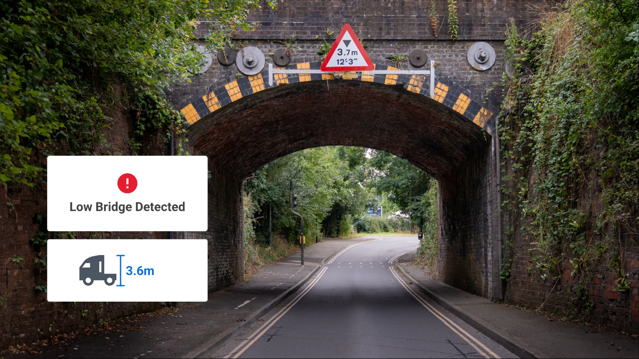
The Peril of Low Bridges
Low bridges are a problem. According to the National Highway Traffic and Safety Administration (NHTSA), around 15,000 bridge strikes happen every year in the US. That’s millions of dollars in infrastructure damages, transportation delays, and insurance payouts. In the UK, an average of five bridge strikes happen daily, racking up £23 million in costs. Low bridges have produced some funny internet memes—like the infamous 11-foot-8 can-opener bridge in Durham, North Carolina. In fact, you may have seen the viral videos of trucks viciously “can-opened” in one, fluid motion!

So, why does this problem exist?
For starters, most commercial drivers don’t know their vehicle height. Sounds crazy, right? But 90% of drivers turnover every year and spend hours on the road, so this is part of the job. More importantly, the data on bridge heights isn’t readily available. It’s not tracked by consumer nav apps, and for the most part reliable documentation on bridge height lives in real-world road signs. Solving this issue also means alerting drivers at just the right second to change course, tailored to their vehicle height and route.
Latent Space
After chatting with our customer Sysco Great Britain—the UK’s leading food service distributor— about the challenge of low bridges, we started toying with the idea of using geofences and cloud microservices to fix the low bridge problem. We prototyped the geofence approach, but quickly scrapped it. For starters, geofences struggled with discernment in perpendicular scenarios. They failed at understanding if a truck was on an overpass or under it. On top of that, the cloud-to-cab lag was a dealbreaker. Notifications would arrive too late to alert the driver before the bridge. Plus, if a driver hit a cellular dead zone like a tunnel or rural road, the bridge alerts would have gone dark.
The Alpha: Edge AI
To solve this hurdle, we moved the detection to run on-device in the camera firmware on the truck instead of relying on cloud processing. We have millions of connected cameras around the world! We built a low bridge strike manager that runs on firmware and multimodal map context to detect risk at the edge. This meant shifting our thinking from infinite cloud compute resources to constrained, embedded resources. We built on our existing proprietary camera module map framework that already runs on-device. It’s what we use to alert drivers about things like speeding detections and stop sign locations.
From there, we built out the bridge dataset:
Map Tile Framework: This on-device tiling/caching system for geospatial data works offline and keeps our storage footprint relatively low by loading only the small map chunks needed for a truck’s current location. Our homegrown bridge database is curated from multiple data sources and is sharded and used to preload only the relevant geospatial tiles onto the device.
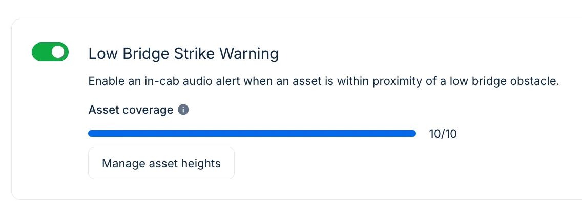
Calculating Buffers: To get the vehicle height right, we don’t guess! We use the truck height confirmed by the driver or fleet during the pre-trip checks performed in Samsara, and we stack a safety buffer on top of that real-world number.
Intent Detection: It’s not enough to be near a bridge. We use proprietary on-device heuristics tied to maps, roads, and other environmental factors to confirm the driver is on a plausible path to a low-clearance road segment. That rules out trucks near bridges but unlikely to take them, reducing false positives.
Interpreting the World with Vision Language Models (VLMs)
The algorithm is only half the battle. The other half is the data. Government datasets are outdated and fragmented. So we built our own source of truth! We ingested sample dash cam footage and large-scale location points to identify real-world edge cases—all processed in our secure production environment. From there, we applied VLMs as a force-multiplier to interpret the physical world. By training our models on diverse, real-world data, identified bridge signs, and extracted height data in a structured format to enrich our maps. These models surfaced bridge candidates at lightning speed, allowing our team to verify and structure the data through rapid tooling. AI and data scale accelerate our understanding of the world and engineers close the loop.
The Result
We shipped Low Bridge Strike Alerts at the end of last year as part of our broader focus on keeping frontline workers safe. The end-product feels simple, but it’s powered by sophisticated orchestration between cloud and edge firmware, and multimodal AI.
Huge kudos to Dorian Wysocki, lead engineer on this project, for applying first principles thinking to develop an elegant solution.
Our customers love it. Andrew Valenzuela, Director of Safety & Compliance at Ferraro Foods told us that:
“Low bridges became a major issue, damaging our vehicles and causing out-of-service time and repair costs…Since launching Samsara’s Commercial Navigation, we’ve seen a direct correlation with a decrease in overhead incidents at low bridges and a decrease in violations for operating on restricted roads.”
I love connecting with folks solving the physical world’s toughest problems. See you in the field!
View open rolesGet the latest from Samsara
Subscribe nowRead more

When AI brings your loved one home safe

Vice President of Artificial Intelligence


Humans, Machines, and the Road Ahead: HumanX Reflections

Senior Vice President of Product


Behind the build: Smart Trailers and Connected Equipment at Samsara

Vice President of Product & Engineering, Connected Equipment

From idea to impact: Solutions built and shipped by our 2025 interns

Director, Firmware Engineering

